Gas station nearby Lavadero ELIO
Paraguay
Gas station nearby Lavadero ELIO
Lavadero ELIO
Encarnacion, Paraguay
contacts phone
:
+595
Latitude:
-27.3307601
, Longitude:
-55.8636429
larger map & directions
read more
nearest Gas station
466 m
Petrobras
Encarnación
Gas station
read more
521 m
EESS PETROBRAS CASA BAKUNOVICH S.A.
Cerro Corá, Encarnación
Gas station
read more
578 m
Esso Shop Irrazabal
Avenida Irrazábal, Encarnación
Gas station
read more
627 m
Estación Puma Energy
Avenida Caballero, Encarnación
Gas station
read more
667 m
Petrobras Bakunovich
Avenida Bernardino Caballero, Encarnación
Gas station
read more
899 m
Petrosur
Avda. Caballero y Posadas, Encarnación
Gas station
read more
1.033 km
Copetrol
Avenida Caballero, Encarnación
Gas station
read more
1.061 km
Estación Puma Energy
General Cabañas, Encarnación
Gas station
read more
1.187 km
Petrobras Ruta 6ta.
6, Encarnación
Gas station
read more
1.351 km
Estación Barcos Y Rodados
Padre Bolik, Encarnación
Gas station
read more
1.586 km
Boats and Rodados
Encarnacion
Gas station
read more
2.006 km
Petrobras Irrazabal
Encarnación
Gas station
read more
2.503 km
Copetrol San Pedro
Avenida Victor Matiauda, Encarnación
Gas station
read more
2.618 km
PETROSUR
6, Encarnación
Gas station
read more
2.641 km
Petrosur Santa Maria
Encarnacion
Gas station
read more
2.917 km
Copetrol
1, Encarnación
Gas station
read more
2.938 km
IMPERIO S.R.L Bissa Shop
Encarnacion
Gas station
read more
3.196 km
Boat and Rodados
Carlos Hrase, Encarnación
Gas station
read more
3.969 km
Estacion Petrobras
Encarnacion
Gas station
read more
4.021 km
Estacion Barcos y Rodados
Encarnacion
Gas station
read more
4.529 km
FHS Entregas De Gas, Petrogas SACI
Ruta 6, km 3,5, Encarnación
Gas station
read more
11.413 km
Estación Puma Energy
6
Gas station
read more
11.868 km
Petrobras
Paraguay
Gas station
read more
11.991 km
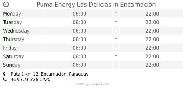
Puma Energy Las Delicias
Ruta 1 km 12
Gas station
read more
15.83 km
Estacion De Servicio Ecop
Camino a Uru Sapucai, Encarnación
Gas station
read more
📑
all categories
Accounting
Administrative area level 1
Administrative area level 2
Airport
Amusement park
Aquarium
Art gallery
Atm
Bakery
Bank
Bar
Beauty salon
Bicycle store
Book store
Bowling alley
Bus station
Cafe
Campground
Car dealer
Car rental
Car repair
Car wash
Casino
Cemetery
Church
City hall
Clothing store
Colloquial area
Convenience store
Courthouse
Dentist
Department store
Doctor
Electrician
Electronics store
Embassy
Establishment
Finance
Fire station
Florist
Food
Funeral home
Furniture store
Gas station
General contractor
Grocery or supermarket
Gym
Hair care
Hardware store
Health
Hindu Temple
Home goods store
Hospital
Insurance agency
Jewelry store
Laundry
Lawyer
Library
Liquor store
Local government office
Locality
Locksmith
Lodging
Meal delivery
Meal takeaway
Mosque
Movie rental
Movie theater
Moving company
Museum
Natural feature
Neighborhood
Night club
Painter
Park
Parking
Pet store
Pharmacy
Physiotherapist
Place of worship
Plumber
Point of interest
Police
Political
Post office
Premise
Real estate agency
Restaurant
Roofing contractor
Route
Rv park, camping
School
Shoe store
Shopping mall
Spa
Stadium
Storage
Store
Subpremise
Supermarket
Synagogue
Taxi stand
Train station
Transit station
Travel agency
University
Veterinary care
Zoo
sublocality level 1
↑