Establishment nearby Despensa Niño Jesus
Paraguay
Establishment nearby Despensa Niño Jesus
Despensa Niño Jesus
H9M6+3Q7, Hernandarias, Paraguay
contacts phone
:
+595
Latitude:
-25.4173421
, Longitude:
-54.6380903
larger map & directions
read more
nearest Establishment
193 m
La Kasita
H9J6+CG4, Hernandarias
Lodging
Point of interest
Establishment
read more
349 m
Quinta Doña Digna
H9P7+762, Hernandarias
Lodging
Point of interest
Establishment
read more
512 m
Apaeh Hernandarias
H9P7+PJJ, Hernandarias
Hospital
Health
Point of interest
Establishment
read more
646 m
Burger Star
12 de junio, Hernandarias
Restaurant
Food
Point of interest
Establishment
read more
717 m
Hamburguesas Rodney
H9M3+5W2, Unnamed Road, Hernandarias
Restaurant
Food
Point of interest
Establishment
read more
732 m
Puesto de Salud Caacupemi
H9M3+3RX, Hernandarias
Hospital
Health
Point of interest
Establishment
read more
793 m
Comercial LUJAN II Del Grupo J.B
Colombia & Uruguay, Hernandarias
Supermarket
Shopping mall
Grocery or supermarket
Store
Food
Point of interest
Establishment
read more
797 m
Hotel, Dpto y Hospedaje BZ
H9M9+GVX, Hernandarias
Lodging
Point of interest
Establishment
read more
902 m
Hotel Tacuru Pucu
H9R5+4F5, Unnamed Rd, Hernandarias
Lodging
Point of interest
Establishment
read more
978 m
Gustavo Eckert
H9R5+865, Avenida El Mensú, Hernandarias
Lodging
Point of interest
Establishment
read more
1000 m
Hotel Fieles
H9R8+3WM, Hernandarias
Lodging
Point of interest
Establishment
read more
1.002 km
Cami diversiones
H9H3+F5M, Unnamed Road, Hernandarias
Lodging
Point of interest
Establishment
read more
1.067 km
Hotel Lion
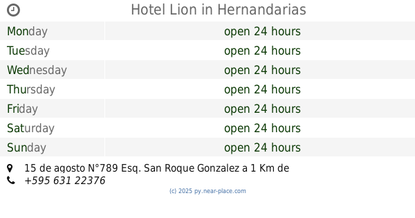
15 de agosto N°789 Esq. San Roque Gonzalez a 1 Km de la Represa de Itaipu, Hernandarias
Lodging
Point of interest
Establishment
read more
1.08 km
Comercial La Familia''
Calle 1, Hernandarias
Supermarket
Grocery or supermarket
Food
Point of interest
Store
Establishment
read more
1.247 km
Americas Hot Dog -
Avenida Paraguay esq, Hernandarias
Restaurant
Food
Point of interest
Establishment
read more
📑
all categories
Accounting
Administrative area level 1
Administrative area level 2
Airport
Amusement park
Aquarium
Art gallery
Atm
Bakery
Bank
Bar
Beauty salon
Bicycle store
Book store
Bowling alley
Bus station
Cafe
Campground
Car dealer
Car rental
Car repair
Car wash
Casino
Cemetery
Church
City hall
Clothing store
Colloquial area
Convenience store
Courthouse
Dentist
Department store
Doctor
Electrician
Electronics store
Embassy
Establishment
Finance
Fire station
Florist
Food
Funeral home
Furniture store
Gas station
General contractor
Grocery or supermarket
Gym
Hair care
Hardware store
Health
Hindu Temple
Home goods store
Hospital
Insurance agency
Jewelry store
Laundry
Lawyer
Library
Liquor store
Local government office
Locality
Locksmith
Lodging
Meal delivery
Meal takeaway
Mosque
Movie rental
Movie theater
Moving company
Museum
Natural feature
Neighborhood
Night club
Painter
Park
Parking
Pet store
Pharmacy
Physiotherapist
Place of worship
Plumber
Point of interest
Police
Political
Post office
Premise
Real estate agency
Restaurant
Roofing contractor
Route
Rv park, camping
School
Shoe store
Shopping mall
Spa
Stadium
Storage
Store
Subpremise
Supermarket
Synagogue
Taxi stand
Train station
Transit station
Travel agency
University
Veterinary care
Zoo
sublocality level 1
↑